


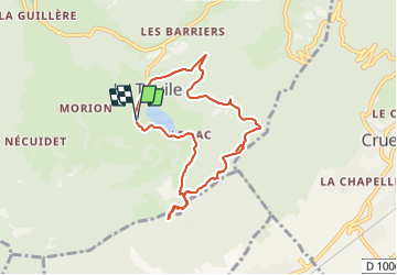
la thuile Roc de Manettaz

papou73
User

Length
7.9 km

Max alt
1080 m

Uphill gradient
324 m
Km-Effort
12.2 km

Min alt
879 m

Downhill gradient
322 m
Boucle
Yes
Creation date :
2021-10-07 05:56:46.991
Updated on :
2021-10-07 09:16:06.704
2h30
Difficulty : Difficult

FREE GPS app for hiking
 SityTrail
IGN / Geographical institutes
SityTrail Plus
The world is yours!
About
Trail Walking of 7.9 km to be discovered at Auvergne-Rhône-Alpes, Savoy, La Thuile. This trail is proposed by papou73.
Positioning
Country:
France
Region :
Auvergne-Rhône-Alpes
Department/Province :
Savoy
Municipality :
La Thuile
Location:
Unknown
Start:(Dec)
Start:(UTM)
269902 ; 5046037 (32T) N.
Comments